
Guidebook for Cagliari
Visite Turistiche
The slow, thoughtful footsteps of the monks and the ancient, evocative liturgical chants run and echo through its shaded corridors. The cloister of San Domenico is a perfect model of medieval architecture in Cagliari: right in the centre, in the district of Villanova, at the foot of Castello. It embodies the spirit of the district, anchored in the religious tradition that comes alive every Lent in the processions of the Mysteries. The convent was built at the expense of the kings of Aragon and in 1533 Charles V granted it the title of royal. The cloister and adjacent crypt represent what has survived of the monumental complex destroyed by bombing in 1943. The post-war reconstruction preserved the original structures below the new building as a crypt and spared little of the ancient church.
The plan of the cloister is a square 25 metres per side: two original arms are preserved, one from the 15th century, the other from the 16th century. The eastern and northern arms are from the reconstruction ordered by Philip II of Spain in 1598. On the western wing are seven 15th-century cross-vaulted chapels in Catalan Gothic style, resting on capitals carved with plant motifs and animal figures. Once through the doorway and up the steps, you will be overwhelmed by its white vaults. The entire perimeter is open to a garden with round arches, adorned with succulent plants. You can sit on a step and watch the bustle of meditating monks, attend a service or one of the concerts often hosted in the crypt, which on occasion is also a venue for photographic exhibitions and shows. Or you can simply stroll through the corridors, in an atmosphere steeped in devotion and mysticism, before setting off again to discover Cagliari and indulge in an afternoon of shopping in the centre. From Via Manno, you can continue through the historic quarters: from the inimitable bastion of Santa Croce to the towers of the Elephant and San Pancrazio, to the narrow streets and monuments of Stampace. From the bastion of saint Remy to the elegant shopping streets and other religious buildings of Villanova, such as the churches of sant'Anna and sant'Antonio, to the characteristic streets full of typical restaurants and shops of the Marina, overlooking the port with the splendid buildings of via Roma, including the Palazzo Civico. Or head towards the hill of Bonaria, visiting the basilicas of San Saturnino, the oldest in Sardinia, and Nostra Signora di Bonaria, the island's Christian temple, and next to the monumental cemetery.
I passi lenti e meditati dei frati e gli antichi e suggestivi canti liturgici percorrono e fanno risuonare i suoi corridoi ombreggiati. Il chiostro di san Domenico è un perfetto modello di architettura medioevale a Cagliari: in pieno centro, nel quartiere di Villanova, ai piedi di Castello. Incarna lo spirito del rione, ancorato alla tradizione religiosa che in ogni Quaresima riprende vita nelle processioni dei Misteri. Il convento fu costruito a spese dei sovrani d’Aragona e nel 1533 Carlo V gli concesse il titolo di regio. Chiostro e cripta adiacente rappresentano quanto è sopravvissuto del complesso monumentale distrutto dai bombardamenti del 1943. La ricostruzione del Dopoguerra ha preservato come cripta le strutture originarie al di sotto del nuovo edificio e ha risparmiato poco dell’antica chiesa.
La pianta del chiostro è un quadrato di 25 metri per lato: si conservano due bracci originari, uno del XV, l’altro del XVI secolo. I bracci orientale e settentrionale sono derivanti dalla ricostruzione voluta da Filippo II di Spagna nel 1598. Sull’ala occidentale ci sono sette cappelle quattrocentesche voltate a crociera in stile gotico catalano, poggianti su capitelli scolpiti a motivi vegetali e figure animali. Una volta superato il portone e percorsi i gradini, sarai sovrastato dalle sue candide volte. L’intero perimetro è aperto su un giardino con archi a tutto sesto, ornato da piante grasse. Potrai sederti su un gradino a osservare il viavai dei frati meditanti, assistere a una funzione o a uno dei concerti spesso ospitati nella cripta, che all’occasione è anche location di mostre fotografiche e spettacoli. Oppure, semplicemente, potrai passeggiare nei corridoi, in un’atmosfera intrisa di devozione e misticismo, prima di ripartire alla scoperta di Cagliari e dedicarti a un pomeriggio di shopping in centro. Da via Manno potrai proseguire per i quartieri storici: dall’inimitabile bastione di santa Croce alle torri dell’Elefante e di san Pancrazio, sino alle viuzze ai monumenti di Stampace. Dal bastione di saint Remy alle eleganti vie dello shopping e agli altri edifici di culto di Villanova, come le chiese di sant’Anna e di sant’Antonio, sino alle caratteristiche strade piene di ristoranti tipici e negozi della Marina, affacciata sul porto con gli splendidi palazzi di via Roma, tra cui il Palazzo Civico. Oppure in direzione del colle di Bonaria, visitando le basiliche di san Saturnino, la più antica della Sardegna, e di Nostra Signora di Bonaria, tempio cristiano dell’Isola, e accanto il cimitero monumentale.
9 Recomendado por los habitantes de la zona
Convento di San Domenico
4 Piazza San DomenicoThe slow, thoughtful footsteps of the monks and the ancient, evocative liturgical chants run and echo through its shaded corridors. The cloister of San Domenico is a perfect model of medieval architecture in Cagliari: right in the centre, in the district of Villanova, at the foot of Castello. It embodies the spirit of the district, anchored in the religious tradition that comes alive every Lent in the processions of the Mysteries. The convent was built at the expense of the kings of Aragon and in 1533 Charles V granted it the title of royal. The cloister and adjacent crypt represent what has survived of the monumental complex destroyed by bombing in 1943. The post-war reconstruction preserved the original structures below the new building as a crypt and spared little of the ancient church.
The plan of the cloister is a square 25 metres per side: two original arms are preserved, one from the 15th century, the other from the 16th century. The eastern and northern arms are from the reconstruction ordered by Philip II of Spain in 1598. On the western wing are seven 15th-century cross-vaulted chapels in Catalan Gothic style, resting on capitals carved with plant motifs and animal figures. Once through the doorway and up the steps, you will be overwhelmed by its white vaults. The entire perimeter is open to a garden with round arches, adorned with succulent plants. You can sit on a step and watch the bustle of meditating monks, attend a service or one of the concerts often hosted in the crypt, which on occasion is also a venue for photographic exhibitions and shows. Or you can simply stroll through the corridors, in an atmosphere steeped in devotion and mysticism, before setting off again to discover Cagliari and indulge in an afternoon of shopping in the centre. From Via Manno, you can continue through the historic quarters: from the inimitable bastion of Santa Croce to the towers of the Elephant and San Pancrazio, to the narrow streets and monuments of Stampace. From the bastion of saint Remy to the elegant shopping streets and other religious buildings of Villanova, such as the churches of sant'Anna and sant'Antonio, to the characteristic streets full of typical restaurants and shops of the Marina, overlooking the port with the splendid buildings of via Roma, including the Palazzo Civico. Or head towards the hill of Bonaria, visiting the basilicas of San Saturnino, the oldest in Sardinia, and Nostra Signora di Bonaria, the island's Christian temple, and next to the monumental cemetery.
I passi lenti e meditati dei frati e gli antichi e suggestivi canti liturgici percorrono e fanno risuonare i suoi corridoi ombreggiati. Il chiostro di san Domenico è un perfetto modello di architettura medioevale a Cagliari: in pieno centro, nel quartiere di Villanova, ai piedi di Castello. Incarna lo spirito del rione, ancorato alla tradizione religiosa che in ogni Quaresima riprende vita nelle processioni dei Misteri. Il convento fu costruito a spese dei sovrani d’Aragona e nel 1533 Carlo V gli concesse il titolo di regio. Chiostro e cripta adiacente rappresentano quanto è sopravvissuto del complesso monumentale distrutto dai bombardamenti del 1943. La ricostruzione del Dopoguerra ha preservato come cripta le strutture originarie al di sotto del nuovo edificio e ha risparmiato poco dell’antica chiesa.
La pianta del chiostro è un quadrato di 25 metri per lato: si conservano due bracci originari, uno del XV, l’altro del XVI secolo. I bracci orientale e settentrionale sono derivanti dalla ricostruzione voluta da Filippo II di Spagna nel 1598. Sull’ala occidentale ci sono sette cappelle quattrocentesche voltate a crociera in stile gotico catalano, poggianti su capitelli scolpiti a motivi vegetali e figure animali. Una volta superato il portone e percorsi i gradini, sarai sovrastato dalle sue candide volte. L’intero perimetro è aperto su un giardino con archi a tutto sesto, ornato da piante grasse. Potrai sederti su un gradino a osservare il viavai dei frati meditanti, assistere a una funzione o a uno dei concerti spesso ospitati nella cripta, che all’occasione è anche location di mostre fotografiche e spettacoli. Oppure, semplicemente, potrai passeggiare nei corridoi, in un’atmosfera intrisa di devozione e misticismo, prima di ripartire alla scoperta di Cagliari e dedicarti a un pomeriggio di shopping in centro. Da via Manno potrai proseguire per i quartieri storici: dall’inimitabile bastione di santa Croce alle torri dell’Elefante e di san Pancrazio, sino alle viuzze ai monumenti di Stampace. Dal bastione di saint Remy alle eleganti vie dello shopping e agli altri edifici di culto di Villanova, come le chiese di sant’Anna e di sant’Antonio, sino alle caratteristiche strade piene di ristoranti tipici e negozi della Marina, affacciata sul porto con gli splendidi palazzi di via Roma, tra cui il Palazzo Civico. Oppure in direzione del colle di Bonaria, visitando le basiliche di san Saturnino, la più antica della Sardegna, e di Nostra Signora di Bonaria, tempio cristiano dell’Isola, e accanto il cimitero monumentale.
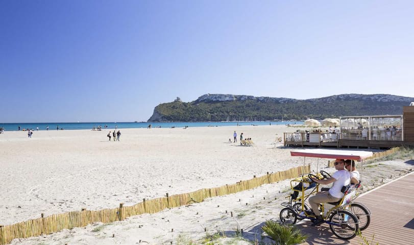
Until the beginning of the 20th century, the people of Cagliari preferred the western part of the Gulf of the Angels, then little by little they appreciated its white dunes, the first bathing establishments, kiosks and a summer colony sprang up, and finally the famous multicoloured huts (removed altogether in 1986). Over time, they populated it more and more, until it took on the name 'beach of the hundred thousand'. Today, Poetto is the undisputed 'sea' of the Cagliari hinterland, one of the largest city beaches in Europe, as well as the most beautiful and frequented on the island, a favourite destination for visitors to the capital, in summer and on any sunny day during the rest of the year: a must-see even if only for a coffee or an aperitif accompanied by the sea breeze.
Just a few kilometres from the centre and the port of Cagliari, the beach stretches from the secluded and relaxing Margine Rosso, in the Quartu Sant'Elena coastline, to the Sella del Diavolo (Devil's Saddle), which adds to its charm by dominating Marina Piccola from above: a walk in the small harbour is not to be missed. From the Spanish tower at the top, known as 'del poeta' (of the poet), perhaps derives the name of the littoral, although the most likely hypothesis is the derivation from the Spanish puerto (port). You can climb to the 17th-century tower by walking up the promontory from Calamosca, a one-hour walk that is beautiful at night. On the opposite coast of the 'Sella' lie the delightful, sheltered beaches of Calamosca and Cala Fighera.
The Poetto beach is wide throughout, the water is clear and the seabed sandy and shallow for tens of metres, ideal for children's play. The shore is an irresistible attraction for long walks. Behind it, you can walk, skate or cycle along a state-of-the-art promenade - perfect for jogging, biking, rollerblading and skateboarding -, while the characteristic kiosks by the sand offer refreshments and entertainment. Toilets and showers are available and there is no shortage of spaces reserved for dogs. The connection to the city is easy and the services efficient: from bathing establishments to the diving centre, from sailing schools to boat rentals, from beach tennis and volleyball courts to canoe trips, from fast food outlets to restaurants, from commercial activities to the amusement park open all year round. The lido is an excellent beach break for wave surfing and kite surfing, for which it hosts world-class events, as well as a venue for nightlife, one of the main summer nightlife venues in the vast area: live music and dance lessons, clubs and discos.
The extension of the beach is equally divided between the almost four kilometres of Quartu coastline and the four of the Cagliari part, subdivided into 'stops', which derive from the tram stops, replaced in more recent times by buses. The 'first stop' has a very shallow seabed, the 'second' and 'third' are home to the historic D'Aquila and Lido establishments, the 'fourth' houses those of the police force, and from the 'fifth', where the Spanish tower stands, to the terminus there is an expanse of 'free' sand. The boundary with the Quartu coastline is 'La Bussola', the name of a club that is no longer active. From here the free beach alternates with welcoming, well-equipped establishments.
From the beach you will quickly reach the 'salt roads' by (slightly) extending the walk to the Molentargius-Saline park, which has an entrance on the seafront. You will be spoilt for choice for the excursion to the protected area - guided and free tours by bike and on foot, boat itineraries along the canals of the former salt pans, electric buses - and you will have a unique experience between historical and scientific knowledge through one of the most beautiful and important natural sites on the island, an oasis just a few steps from the city, the favourite home of the pink flamingos, which stop and nest here. Poetto and Molentargius are also closely linked by the millenary salt-mining activity, which began in Roman times and stopped in 1985.
Sino a inizio XX secolo i cagliaritani gli preferivano la parte occidentale del golfo degli Angeli, poi a poco a poco ne apprezzarono le dune bianche, sorsero i primi stabilimenti, i chioschi e una colonia estiva, infine i celebri variopinti casotti (rimossi del tutto nel 1986). Col tempo l’hanno popolata sempre più, sino a farle assumere il nome di ‘spiaggia dei centomila’. Oggi il Poetto è l’indiscusso ‘mare’ dell’hinterland cagliaritano, una delle spiagge cittadine maggiori d’Europa, nonché più belle e frequentate dell’Isola, meta preferita dei visitatori del capoluogo, in estate e in qualsiasi giornata di sole nel resto dell’anno: tappa obbligatoria anche soltanto per un caffè o un aperitivo accompagnato dalla brezza marina.
A pochissimi chilometri dal centro e dal porto di Cagliari, la spiaggia si estende dall’appartato e rilassante Margine Rosso, nel litorale di Quartu Sant’Elena, sino alla Sella del Diavolo, che ne accresce il fascino dominando dall’alto Marina Piccola: immancabile la passeggiata nel porticciolo. Dalla torre spagnola in cima, detta ‘del poeta’, deriva forse il nome del litorale, anche se l’ipotesi più verosimile è la derivazione dallo spagnolo puerto (porto). Potrai salire sino alla torre seicentesca percorrendo il promontorio da Calamosca, con un percorso di un’ora, bellissimo di notte. Sulla costa opposta della ‘Sella’ si nascondono le deliziose e riparate spiaggette di Calamosca e di Cala Fighera.
L’arenile del Poetto è ampio in tutta la sua estensione, l’acqua è limpida e il fondale sabbioso e basso per decine di metri, ideale per il gioco dei bambini. La riva è un’irresistibile attrazione per lunghe passeggiate. Alle spalle passeggerai a piedi, coi pattini o in bici in un modernissimo lungomare – perfetto per jogging, biking, rollerblade e skateboard -, mentre i caratteristici chioschetti a ridosso della sabbia offrono ristoro e animazione. Sono a disposizione bagni e docce e non mancano spazi riservati ai cani. Il collegamento con la città è agevole e i servizi efficienti: dagli stabilimenti balneari al diving center, dalle scuole di vela all’affitto di natanti, dai campi da beach tennis e volley alle escursioni in canoa, dai fast food ai ristoranti, dalle attività commerciali al luna park aperto tutto l’anno. Il lido è un eccellente beach break per surf da onda e kite surf, di cui ospita eventi di livello mondiale, nonché teatro di vita notturna, uno dei principali luoghi della movida estiva dell’area vasta: musica dal vivo e lezioni di ballo, locali e discoteche.
L’estensione della spiaggia è equamente divisa tra i quasi quattro chilometri di litorale di Quartu e i quattro della parte cagliaritana, suddivisa in ‘fermate’, che derivano dalle soste del tram, sostituito in tempi più recenti dagli autobus. La ‘prima fermata’ ha fondale bassissimo, ‘seconda’ e ‘terza’ sono sede degli stabilimenti storici del D’Aquila e del Lido, la ‘quarta’ ospita quelli delle forze dell’ordine, dalla ‘quinta’, dove sorge la torre spagnola, sino al capolinea c’è una distesa di sabbia ‘libera’. Il confine col litorale di Quartu è ‘La Bussola’, nome di un locale non più attivo. Da qui la spiaggia libera si alterna ad accoglienti e attrezzati stabilimenti.
Dalla spiaggia giungerai rapidamente alle ‘vie del sale’ allungando (di poco) la passeggiata sino al parco di Molentargius-Saline, che ha un ingresso sul lungomare. Avrai l’imbarazzo della scelta per l’escursione nell’area protetta - tour guidati e liberi in bici e a piedi, itinerari in battello lungo i canali delle ex saline, bus elettrici – e farai un’esperienza unica tra conoscenza storica e scientifica attraverso uno dei siti naturalistici più belli e importanti dell’Isola, un’oasi a pochi passi dalla città, dimora preferita dei fenicotteri rosa, che qui sostano e nidificano. Poetto e Molentargius sono strettamente legati anche dalla millenaria attività saliniera, iniziata in epoca romana e interrottasi nel 1985.
330 Recomendado por los habitantes de la zona
Poetto
2 Piazza degli ArcipelaghiUntil the beginning of the 20th century, the people of Cagliari preferred the western part of the Gulf of the Angels, then little by little they appreciated its white dunes, the first bathing establishments, kiosks and a summer colony sprang up, and finally the famous multicoloured huts (removed altogether in 1986). Over time, they populated it more and more, until it took on the name 'beach of the hundred thousand'. Today, Poetto is the undisputed 'sea' of the Cagliari hinterland, one of the largest city beaches in Europe, as well as the most beautiful and frequented on the island, a favourite destination for visitors to the capital, in summer and on any sunny day during the rest of the year: a must-see even if only for a coffee or an aperitif accompanied by the sea breeze.
Just a few kilometres from the centre and the port of Cagliari, the beach stretches from the secluded and relaxing Margine Rosso, in the Quartu Sant'Elena coastline, to the Sella del Diavolo (Devil's Saddle), which adds to its charm by dominating Marina Piccola from above: a walk in the small harbour is not to be missed. From the Spanish tower at the top, known as 'del poeta' (of the poet), perhaps derives the name of the littoral, although the most likely hypothesis is the derivation from the Spanish puerto (port). You can climb to the 17th-century tower by walking up the promontory from Calamosca, a one-hour walk that is beautiful at night. On the opposite coast of the 'Sella' lie the delightful, sheltered beaches of Calamosca and Cala Fighera.
The Poetto beach is wide throughout, the water is clear and the seabed sandy and shallow for tens of metres, ideal for children's play. The shore is an irresistible attraction for long walks. Behind it, you can walk, skate or cycle along a state-of-the-art promenade - perfect for jogging, biking, rollerblading and skateboarding -, while the characteristic kiosks by the sand offer refreshments and entertainment. Toilets and showers are available and there is no shortage of spaces reserved for dogs. The connection to the city is easy and the services efficient: from bathing establishments to the diving centre, from sailing schools to boat rentals, from beach tennis and volleyball courts to canoe trips, from fast food outlets to restaurants, from commercial activities to the amusement park open all year round. The lido is an excellent beach break for wave surfing and kite surfing, for which it hosts world-class events, as well as a venue for nightlife, one of the main summer nightlife venues in the vast area: live music and dance lessons, clubs and discos.
The extension of the beach is equally divided between the almost four kilometres of Quartu coastline and the four of the Cagliari part, subdivided into 'stops', which derive from the tram stops, replaced in more recent times by buses. The 'first stop' has a very shallow seabed, the 'second' and 'third' are home to the historic D'Aquila and Lido establishments, the 'fourth' houses those of the police force, and from the 'fifth', where the Spanish tower stands, to the terminus there is an expanse of 'free' sand. The boundary with the Quartu coastline is 'La Bussola', the name of a club that is no longer active. From here the free beach alternates with welcoming, well-equipped establishments.
From the beach you will quickly reach the 'salt roads' by (slightly) extending the walk to the Molentargius-Saline park, which has an entrance on the seafront. You will be spoilt for choice for the excursion to the protected area - guided and free tours by bike and on foot, boat itineraries along the canals of the former salt pans, electric buses - and you will have a unique experience between historical and scientific knowledge through one of the most beautiful and important natural sites on the island, an oasis just a few steps from the city, the favourite home of the pink flamingos, which stop and nest here. Poetto and Molentargius are also closely linked by the millenary salt-mining activity, which began in Roman times and stopped in 1985.
Sino a inizio XX secolo i cagliaritani gli preferivano la parte occidentale del golfo degli Angeli, poi a poco a poco ne apprezzarono le dune bianche, sorsero i primi stabilimenti, i chioschi e una colonia estiva, infine i celebri variopinti casotti (rimossi del tutto nel 1986). Col tempo l’hanno popolata sempre più, sino a farle assumere il nome di ‘spiaggia dei centomila’. Oggi il Poetto è l’indiscusso ‘mare’ dell’hinterland cagliaritano, una delle spiagge cittadine maggiori d’Europa, nonché più belle e frequentate dell’Isola, meta preferita dei visitatori del capoluogo, in estate e in qualsiasi giornata di sole nel resto dell’anno: tappa obbligatoria anche soltanto per un caffè o un aperitivo accompagnato dalla brezza marina.
A pochissimi chilometri dal centro e dal porto di Cagliari, la spiaggia si estende dall’appartato e rilassante Margine Rosso, nel litorale di Quartu Sant’Elena, sino alla Sella del Diavolo, che ne accresce il fascino dominando dall’alto Marina Piccola: immancabile la passeggiata nel porticciolo. Dalla torre spagnola in cima, detta ‘del poeta’, deriva forse il nome del litorale, anche se l’ipotesi più verosimile è la derivazione dallo spagnolo puerto (porto). Potrai salire sino alla torre seicentesca percorrendo il promontorio da Calamosca, con un percorso di un’ora, bellissimo di notte. Sulla costa opposta della ‘Sella’ si nascondono le deliziose e riparate spiaggette di Calamosca e di Cala Fighera.
L’arenile del Poetto è ampio in tutta la sua estensione, l’acqua è limpida e il fondale sabbioso e basso per decine di metri, ideale per il gioco dei bambini. La riva è un’irresistibile attrazione per lunghe passeggiate. Alle spalle passeggerai a piedi, coi pattini o in bici in un modernissimo lungomare – perfetto per jogging, biking, rollerblade e skateboard -, mentre i caratteristici chioschetti a ridosso della sabbia offrono ristoro e animazione. Sono a disposizione bagni e docce e non mancano spazi riservati ai cani. Il collegamento con la città è agevole e i servizi efficienti: dagli stabilimenti balneari al diving center, dalle scuole di vela all’affitto di natanti, dai campi da beach tennis e volley alle escursioni in canoa, dai fast food ai ristoranti, dalle attività commerciali al luna park aperto tutto l’anno. Il lido è un eccellente beach break per surf da onda e kite surf, di cui ospita eventi di livello mondiale, nonché teatro di vita notturna, uno dei principali luoghi della movida estiva dell’area vasta: musica dal vivo e lezioni di ballo, locali e discoteche.
L’estensione della spiaggia è equamente divisa tra i quasi quattro chilometri di litorale di Quartu e i quattro della parte cagliaritana, suddivisa in ‘fermate’, che derivano dalle soste del tram, sostituito in tempi più recenti dagli autobus. La ‘prima fermata’ ha fondale bassissimo, ‘seconda’ e ‘terza’ sono sede degli stabilimenti storici del D’Aquila e del Lido, la ‘quarta’ ospita quelli delle forze dell’ordine, dalla ‘quinta’, dove sorge la torre spagnola, sino al capolinea c’è una distesa di sabbia ‘libera’. Il confine col litorale di Quartu è ‘La Bussola’, nome di un locale non più attivo. Da qui la spiaggia libera si alterna ad accoglienti e attrezzati stabilimenti.
Dalla spiaggia giungerai rapidamente alle ‘vie del sale’ allungando (di poco) la passeggiata sino al parco di Molentargius-Saline, che ha un ingresso sul lungomare. Avrai l’imbarazzo della scelta per l’escursione nell’area protetta - tour guidati e liberi in bici e a piedi, itinerari in battello lungo i canali delle ex saline, bus elettrici – e farai un’esperienza unica tra conoscenza storica e scientifica attraverso uno dei siti naturalistici più belli e importanti dell’Isola, un’oasi a pochi passi dalla città, dimora preferita dei fenicotteri rosa, che qui sostano e nidificano. Poetto e Molentargius sono strettamente legati anche dalla millenaria attività saliniera, iniziata in epoca romana e interrottasi nel 1985.
The gateway from the Villanova district to the fortified district of Castello, in the heart of the old city, the bastion, named after the Baron of Saint Remy, the first Piedmontese viceroy, overlooks Piazza Costituzione, at the crossroads of two streets historically used for walking and shopping, Via Garibaldi and Via Manno. It is unmistakably a symbol of Cagliari, one of its most majestic and valuable monumental complexes and a prestigious exhibition space.
The covered promenade and the majestic Umberto I terrace were designed by Giuseppe Costa and Fulgenzio Setti, based on a mid-19th-century idea by architect Gaetano Cima, and built in classical style between 1896 and 1902 on the ancient defensive curtains of the fortified circuit of the medieval city. The bastion of Saint Remy is the result of levelling and reuse of the ancient bastions of the Sperone and the Zecca, built by the Spanish in the second half of the 16th century.
The imposing structure consists of white and yellow limestone columns with Corinthian-style capitals. The long, sweeping main staircase winds its way from the square with several flights of stairs that meet at half height on a wide landing. From here you access the covered promenade, which has vast and brightly lit rooms, painted in bright colours and enclosed by large arches. Under a large archway, which dominates the entire building, there is a further staircase with two circular ramps leading up to the Umberto I terrace, from which you will enjoy a magnificent view over the entire city and towards the sea. The square has two more ramps leading up to the bastion of St Catherine.
The steps and the triumphal arch, damaged by bombing during World War II, were faithfully rebuilt from 1946 onwards. Over the years, the large spaces of the covered promenade were used for a variety of functions: initially as a banquet hall, in wartime as an infirmary and later as a shelter for evacuees. In 1948, it also hosted the first edition of the International Fair of Sardinia.
Porta d’accesso dal quartiere di Villanova a quello fortificato di Castello, nel cuore della città vecchia, il bastione, che deve il nome al barone di Saint Remy, primo viceré piemontese, si affaccia su piazza Costituzione, all’incrocio tra due vie storicamente destinate a passeggiate e shopping, via Garibaldi e via Manno. È inconfondibilmente un simbolo di Cagliari, uno dei suoi complessi monumentali più maestosi e di maggior pregio, nonché prestigioso spazio espositivo.
La passeggiata coperta e la maestosa terrazza Umberto I furono progettate da Giuseppe Costa e Fulgenzio Setti, su un’idea di metà Ottocento dall’architetto Gaetano Cima, e costruite in stile classicheggiante tra 1896 e 1902 sulle antiche cortine difensive del circuito fortificato della città medievale. Il bastione di Saint Remy è il risultato di spianamento e riutilizzo degli antichi bastioni dello Sperone e della Zecca, costruiti dagli spagnoli nella seconda metà del Cinquecento.
L’imponente struttura è composta da colonne in calcare di colore bianco e giallo con capitelli in stile corinzio. Lo scalone principale, lungo e movimentato, si snoda dalla piazza con diverse rampe che si riuniscono a mezza altezza in un ampio pianerottolo. Da qui accederai alla passeggiata coperta, che si sviluppa con vasti e luminosi ambienti, dipinti con colori vivaci e chiusi da grandi arcate. Sotto un grande arco, che domina tutta la costruzione, si trova un’ulteriore scala con due rampe circolari che conduce fino alla terrazza Umberto I da cui godrai di un magnifico panorama su tutta la città e verso il mare. Il piazzale ha altre due rampe che conducono al bastione di santa Caterina.
La scalinata e l’arco di trionfo, danneggiati dai bombardamenti della seconda guerra mondiale, a partire dal 1946 furono fedelmente ricostruiti. Durante il corso degli anni, gli ampi spazi della passeggiata coperta furono adibiti a molteplici funzioni: inizialmente sala banchetti, in epoca bellica infermeria e, successivamente, rifugio per gli sfollati. Nel 1948, inoltre, ospitò la prima edizione della Fiera internazionale della Sardegna.
316 Recomendado por los habitantes de la zona
Bastión de Saint Remy
Piazza CostituzioneThe gateway from the Villanova district to the fortified district of Castello, in the heart of the old city, the bastion, named after the Baron of Saint Remy, the first Piedmontese viceroy, overlooks Piazza Costituzione, at the crossroads of two streets historically used for walking and shopping, Via Garibaldi and Via Manno. It is unmistakably a symbol of Cagliari, one of its most majestic and valuable monumental complexes and a prestigious exhibition space.
The covered promenade and the majestic Umberto I terrace were designed by Giuseppe Costa and Fulgenzio Setti, based on a mid-19th-century idea by architect Gaetano Cima, and built in classical style between 1896 and 1902 on the ancient defensive curtains of the fortified circuit of the medieval city. The bastion of Saint Remy is the result of levelling and reuse of the ancient bastions of the Sperone and the Zecca, built by the Spanish in the second half of the 16th century.
The imposing structure consists of white and yellow limestone columns with Corinthian-style capitals. The long, sweeping main staircase winds its way from the square with several flights of stairs that meet at half height on a wide landing. From here you access the covered promenade, which has vast and brightly lit rooms, painted in bright colours and enclosed by large arches. Under a large archway, which dominates the entire building, there is a further staircase with two circular ramps leading up to the Umberto I terrace, from which you will enjoy a magnificent view over the entire city and towards the sea. The square has two more ramps leading up to the bastion of St Catherine.
The steps and the triumphal arch, damaged by bombing during World War II, were faithfully rebuilt from 1946 onwards. Over the years, the large spaces of the covered promenade were used for a variety of functions: initially as a banquet hall, in wartime as an infirmary and later as a shelter for evacuees. In 1948, it also hosted the first edition of the International Fair of Sardinia.
Porta d’accesso dal quartiere di Villanova a quello fortificato di Castello, nel cuore della città vecchia, il bastione, che deve il nome al barone di Saint Remy, primo viceré piemontese, si affaccia su piazza Costituzione, all’incrocio tra due vie storicamente destinate a passeggiate e shopping, via Garibaldi e via Manno. È inconfondibilmente un simbolo di Cagliari, uno dei suoi complessi monumentali più maestosi e di maggior pregio, nonché prestigioso spazio espositivo.
La passeggiata coperta e la maestosa terrazza Umberto I furono progettate da Giuseppe Costa e Fulgenzio Setti, su un’idea di metà Ottocento dall’architetto Gaetano Cima, e costruite in stile classicheggiante tra 1896 e 1902 sulle antiche cortine difensive del circuito fortificato della città medievale. Il bastione di Saint Remy è il risultato di spianamento e riutilizzo degli antichi bastioni dello Sperone e della Zecca, costruiti dagli spagnoli nella seconda metà del Cinquecento.
L’imponente struttura è composta da colonne in calcare di colore bianco e giallo con capitelli in stile corinzio. Lo scalone principale, lungo e movimentato, si snoda dalla piazza con diverse rampe che si riuniscono a mezza altezza in un ampio pianerottolo. Da qui accederai alla passeggiata coperta, che si sviluppa con vasti e luminosi ambienti, dipinti con colori vivaci e chiusi da grandi arcate. Sotto un grande arco, che domina tutta la costruzione, si trova un’ulteriore scala con due rampe circolari che conduce fino alla terrazza Umberto I da cui godrai di un magnifico panorama su tutta la città e verso il mare. Il piazzale ha altre due rampe che conducono al bastione di santa Caterina.
La scalinata e l’arco di trionfo, danneggiati dai bombardamenti della seconda guerra mondiale, a partire dal 1946 furono fedelmente ricostruiti. Durante il corso degli anni, gli ampi spazi della passeggiata coperta furono adibiti a molteplici funzioni: inizialmente sala banchetti, in epoca bellica infermeria e, successivamente, rifugio per gli sfollati. Nel 1948, inoltre, ospitò la prima edizione della Fiera internazionale della Sardegna.
The terrace of Santa Caterina forms the northernmost appendage of the bastion of Saint Remy. Here you can enjoy one of the many breathtaking panoramic views offered by the Castello district
La terrazza di Santa Caterina costituisce l'appendice più settentrionale del bastione di Saint Remy. Qui si può godere di una delle tante viste panoramiche mozzafiato offerte dal quartiere di Castello
7 Recomendado por los habitantes de la zona
Bastione di Santa Caterina
Via San GiuseppeThe terrace of Santa Caterina forms the northernmost appendage of the bastion of Saint Remy. Here you can enjoy one of the many breathtaking panoramic views offered by the Castello district
La terrazza di Santa Caterina costituisce l'appendice più settentrionale del bastione di Saint Remy. Qui si può godere di una delle tante viste panoramiche mozzafiato offerte dal quartiere di Castello
Named after Santa Maria Assunta, Cagliari Cathedral dominates from Piazza Palazzo the Piazza Carlo Alberto below in the Castello district. It is framed, like a stage set, between the arches of the 19th-century Bastion of Saint Remy. The original layout, dating back to the 12th century, was Pisan but during the 17th century the church was transformed according to Baroque taste. The bell tower, the lintel of the central door and the portals of the transept can be traced back to the original building, while the Baroque façade was redone in 1931. Inside, the 14th-century Black Madonna stands out among the polychrome marble of the church. The sacristy houses the cathedral treasure: objects related to liturgical celebrations (vestments, chalices, ciboria, monstrances, professional crosses), wooden statues and paintings. Particularly significant among the latter are the Triptych of Clement VII, attributed to a Flemish workshop (15th century), the Retable of the Benefactors, created by Neapolitan artists, and the marvellous antependium by Palermo silversmiths.
Intitolata a Santa Maria Assunta, la cattedrale di Cagliari domina da piazza Palazzo la sottostante piazza Carlo Alberto, situata a un livello inferiore nel quartiere Castello. È incorniciata, come in una scenografia, tra le arcate dell’ottocentesco Bastione di Saint Remy. L’impianto originario, risalente al XII secolo, era pisano ma nel corso del Seicento la Chiesa venne trasformata secondo il gusto barocco. La torre campanaria, l’architrave del portone centrale e i portali del transetto sono riconducibili all’edificio originale, mentre la facciata barocca venne rifatta nel 1931. Da vedere, all’interno, la Madonna Nera del XIV secolo che spicca tra i marmi policromi della chiesa. Nella sagrestia è conservato il tesoro della cattedrale: oggetti legati alle celebrazioni liturgiche (paramenti, calici, pissidi, ostensori, croci professionali), statue lignee e dipinti. Tra questi ultimi sono particolarmente significativi il Trittico di Clemente VII, attribuito a una bottega fiamminga (XV secolo), il Retablo dei Beneficiati, creazione di artisti napoletani e il meraviglioso paliotto opera di argentieri palermitani.
168 Recomendado por los habitantes de la zona
Catedral de Santa María de la Asunción y Santa Cecilia
4/a Piazza PalazzoNamed after Santa Maria Assunta, Cagliari Cathedral dominates from Piazza Palazzo the Piazza Carlo Alberto below in the Castello district. It is framed, like a stage set, between the arches of the 19th-century Bastion of Saint Remy. The original layout, dating back to the 12th century, was Pisan but during the 17th century the church was transformed according to Baroque taste. The bell tower, the lintel of the central door and the portals of the transept can be traced back to the original building, while the Baroque façade was redone in 1931. Inside, the 14th-century Black Madonna stands out among the polychrome marble of the church. The sacristy houses the cathedral treasure: objects related to liturgical celebrations (vestments, chalices, ciboria, monstrances, professional crosses), wooden statues and paintings. Particularly significant among the latter are the Triptych of Clement VII, attributed to a Flemish workshop (15th century), the Retable of the Benefactors, created by Neapolitan artists, and the marvellous antependium by Palermo silversmiths.
Intitolata a Santa Maria Assunta, la cattedrale di Cagliari domina da piazza Palazzo la sottostante piazza Carlo Alberto, situata a un livello inferiore nel quartiere Castello. È incorniciata, come in una scenografia, tra le arcate dell’ottocentesco Bastione di Saint Remy. L’impianto originario, risalente al XII secolo, era pisano ma nel corso del Seicento la Chiesa venne trasformata secondo il gusto barocco. La torre campanaria, l’architrave del portone centrale e i portali del transetto sono riconducibili all’edificio originale, mentre la facciata barocca venne rifatta nel 1931. Da vedere, all’interno, la Madonna Nera del XIV secolo che spicca tra i marmi policromi della chiesa. Nella sagrestia è conservato il tesoro della cattedrale: oggetti legati alle celebrazioni liturgiche (paramenti, calici, pissidi, ostensori, croci professionali), statue lignee e dipinti. Tra questi ultimi sono particolarmente significativi il Trittico di Clemente VII, attribuito a una bottega fiamminga (XV secolo), il Retablo dei Beneficiati, creazione di artisti napoletani e il meraviglioso paliotto opera di argentieri palermitani.
Reopened for worship in 2007, the church overlooks a square enclosed by the houses of the former Jewish quarter. The façade, majestic and difficult to photograph, is divided into two levels: the lower one with the main door, surmounted by a curved tympanum, the upper one decorated with pilasters. There are also two bell towers: one is next to the façade, the other is close to the presbytery and has an oriental head. The church was originally a synagogue converted to the worship of Catholicism in the late 15th century and was enlarged and completely transformed in the first half of the 17th century.
Riaperta al culto nel 2007, la chiesa si affaccia su una piazza chiusa tra le case dell’ex quartiere ebraico. La facciata, maestosa e difficile da fotografare, è divisa in due livelli: quello inferiore con il portone, sormontato da un timpano curvo, quello superiore decorato con lesene. Anche i campanili sono due: uno è accanto alla facciata, l’altro è vicino al presbiterio e ha un capolino orientaleggiante. In origine la chiesa era una sinagoga convertita al culto del cattolicesimo a fine ‘400 e fu ampliata e completamente trasformata nella prima metà del ‘600.
Basílica Of The Holy Cross Of The Order Of Saint Maurice
44 Via Corte D'AppelloReopened for worship in 2007, the church overlooks a square enclosed by the houses of the former Jewish quarter. The façade, majestic and difficult to photograph, is divided into two levels: the lower one with the main door, surmounted by a curved tympanum, the upper one decorated with pilasters. There are also two bell towers: one is next to the façade, the other is close to the presbytery and has an oriental head. The church was originally a synagogue converted to the worship of Catholicism in the late 15th century and was enlarged and completely transformed in the first half of the 17th century.
Riaperta al culto nel 2007, la chiesa si affaccia su una piazza chiusa tra le case dell’ex quartiere ebraico. La facciata, maestosa e difficile da fotografare, è divisa in due livelli: quello inferiore con il portone, sormontato da un timpano curvo, quello superiore decorato con lesene. Anche i campanili sono due: uno è accanto alla facciata, l’altro è vicino al presbiterio e ha un capolino orientaleggiante. In origine la chiesa era una sinagoga convertita al culto del cattolicesimo a fine ‘400 e fu ampliata e completamente trasformata nella prima metà del ‘600.
Looking at it from below, at the top of the steps leading to the top of the hill of the same name, the basilica of Our Lady of Bonaria has the same majesty as Montmartre, in Paris. And the physical majesty corresponds in fact to an equally great importance, considering that one is in front of the largest Marian complex in Sardinia. The first stone of the sanctuary that can be seen from the street was laid in 1704. The Latin-cross basilica, with three naves, separated by arcades, a wide transept and a dome over the intersection of the arms, stood next to the church built in the 14th century, where devotion to the miraculous statue has grown over the centuries. Legend has it that in 1370, on a stormy night, a chest was thrown overboard from a ship and, after the storm miraculously stopped, landed on the shore opposite the hill of Bonaria. Inside it carried a wooden statue of a Madonna and Child, who was holding a candle that had miraculously been lit. From then on, veneration for the Madonna of Bonaria spread throughout the island, whose statue is now kept in the altar of the small sanctuary next to the Basilica, near the convent where the friars still live. Curiosity: thanks to this devotion, Cagliari is said to be linked to Buenos Aires, founded in the 16th century by the Spanish conqueror Pedro de Mendoza, who was particularly devoted to Our Madonna of Bonaria.
A guardarla dal basso, in cima alla scalinata che porta in cima all’omonimo colle, la basilica di Nostra Signora di Bonaria ha la stessa maestosità di Montmartre, a Parigi. E alla maestosità fisica corrisponde in effetti un’importanza altrettanto rilevante, considerato che ci si trova davanti al maggiore complesso mariano della Sardegna. La prima pietra del santuario che si vede dalla strada è stata posta nel 1704: la basilica a croce latina, con tre navate, separate da arcate, ampio transetto e una cupola a sovrastare l’incrocio dei bracci, sorgeva accanto alla chiesa costruita nel Trecento, dove nei secoli è cresciuta la devozione per la statua miracolosa. La leggenda narra che nel 1370, in una notte di tempesta una cassa fu buttata in mare da una nave e, dopo aver fatto prodigiosamente fermare la bufera, approdò sulla riva di fronte al colle di Bonaria. All’interno portava la statua di legno di una Madonna con Bambino, il quale aveva in mano una candela rimasta miracolosamente accesa. Da allora in tutta l’isola si diffuse la venerazione per la Madonna di Bonaria, la cui statua oggi è custodita nell’altare del piccolo santuario accanto alla Basilica, vicino al convento nel quale tuttora vivono i frati. Curiosità: grazie a questa devozione, Cagliari sarebbe legata a Buenos Aires, fondata nel Cinquecento dal conquistatore spagnolo Pedro de Mendoza, particolarmente devoto alla Madonna di Bonaria.
58 Recomendado por los habitantes de la zona
Shrine of Our Lady of Bonaria
2 Piazza BonariaLooking at it from below, at the top of the steps leading to the top of the hill of the same name, the basilica of Our Lady of Bonaria has the same majesty as Montmartre, in Paris. And the physical majesty corresponds in fact to an equally great importance, considering that one is in front of the largest Marian complex in Sardinia. The first stone of the sanctuary that can be seen from the street was laid in 1704. The Latin-cross basilica, with three naves, separated by arcades, a wide transept and a dome over the intersection of the arms, stood next to the church built in the 14th century, where devotion to the miraculous statue has grown over the centuries. Legend has it that in 1370, on a stormy night, a chest was thrown overboard from a ship and, after the storm miraculously stopped, landed on the shore opposite the hill of Bonaria. Inside it carried a wooden statue of a Madonna and Child, who was holding a candle that had miraculously been lit. From then on, veneration for the Madonna of Bonaria spread throughout the island, whose statue is now kept in the altar of the small sanctuary next to the Basilica, near the convent where the friars still live. Curiosity: thanks to this devotion, Cagliari is said to be linked to Buenos Aires, founded in the 16th century by the Spanish conqueror Pedro de Mendoza, who was particularly devoted to Our Madonna of Bonaria.
A guardarla dal basso, in cima alla scalinata che porta in cima all’omonimo colle, la basilica di Nostra Signora di Bonaria ha la stessa maestosità di Montmartre, a Parigi. E alla maestosità fisica corrisponde in effetti un’importanza altrettanto rilevante, considerato che ci si trova davanti al maggiore complesso mariano della Sardegna. La prima pietra del santuario che si vede dalla strada è stata posta nel 1704: la basilica a croce latina, con tre navate, separate da arcate, ampio transetto e una cupola a sovrastare l’incrocio dei bracci, sorgeva accanto alla chiesa costruita nel Trecento, dove nei secoli è cresciuta la devozione per la statua miracolosa. La leggenda narra che nel 1370, in una notte di tempesta una cassa fu buttata in mare da una nave e, dopo aver fatto prodigiosamente fermare la bufera, approdò sulla riva di fronte al colle di Bonaria. All’interno portava la statua di legno di una Madonna con Bambino, il quale aveva in mano una candela rimasta miracolosamente accesa. Da allora in tutta l’isola si diffuse la venerazione per la Madonna di Bonaria, la cui statua oggi è custodita nell’altare del piccolo santuario accanto alla Basilica, vicino al convento nel quale tuttora vivono i frati. Curiosità: grazie a questa devozione, Cagliari sarebbe legata a Buenos Aires, fondata nel Cinquecento dal conquistatore spagnolo Pedro de Mendoza, particolarmente devoto alla Madonna di Bonaria.
Built in the 14th century as the residence of the viceroy by order of Peter of Aragon, it is now the seat of the province. Over the centuries, it has undergone various structural changes and in the transition from Habsburg to Savoy domination, the interiors were renovated and the
Costruito nel Trecento e destinato a residenza del viceré per volontà di Pietro d’Aragona, è oggi la sede della Provincia. Nel corso dei secoli ha subito varie modifiche strutturali e nel passaggio dalla dominazione asburgica a quella sabauda anche delle ristrutturazioni degli interni e il rifacimento della facciata.
34 Recomendado por los habitantes de la zona
Palazzo Regio
1 Piazza PalazzoBuilt in the 14th century as the residence of the viceroy by order of Peter of Aragon, it is now the seat of the province. Over the centuries, it has undergone various structural changes and in the transition from Habsburg to Savoy domination, the interiors were renovated and the
Costruito nel Trecento e destinato a residenza del viceré per volontà di Pietro d’Aragona, è oggi la sede della Provincia. Nel corso dei secoli ha subito varie modifiche strutturali e nel passaggio dalla dominazione asburgica a quella sabauda anche delle ristrutturazioni degli interni e il rifacimento della facciata.
The city's first fortifications were the work of the Pisans, but over the course of successive dominations, the towers and walls were consolidated until the end of the 19th century, when part of the walls were demolished. Four towers remain standing: the tower of the Spur, the tower of the Eagle (later incorporated into Boyl Palace, on whose façade are set three cannon balls, a symbol of the attacks received), the tower of San Pancrazio and the tower of the Elephant, so called because of the elephant statue decorating it. Passing under the heavy doors of the tower, one proceeds along the bastion of Santa Croce, towards the church and the former ghetto, from which one can enjoy the view.
Le prime fortificazioni della città sono opera dei Pisani, ma nel corso delle successive dominazioni le torri e le mura sono stati consolidati fino alla fine del XIX secolo, quando parte della cinta muraria fu demolita. Restano in piedi quattro torri: la torre dello Sperone, la torre dell’Aquila (poi incorporata in palazzo Boyl, sulla cui facciata sono incastonate tre palle di cannone, simbolo degli attacchi ricevuti), la torre di San Pancrazio e la torre dell’Elefante, chiamata cosi per la statua dell’elefantino che la decora. Passando sotto le pesanti porte della torre, si procede lungo il bastione di Santa Croce, verso la Chiesa e l’ex ghetto, da cui godere del panorama.
72 Recomendado por los habitantes de la zona
Torre di San Pancrazio
Piazza dell' IndipendenzaThe city's first fortifications were the work of the Pisans, but over the course of successive dominations, the towers and walls were consolidated until the end of the 19th century, when part of the walls were demolished. Four towers remain standing: the tower of the Spur, the tower of the Eagle (later incorporated into Boyl Palace, on whose façade are set three cannon balls, a symbol of the attacks received), the tower of San Pancrazio and the tower of the Elephant, so called because of the elephant statue decorating it. Passing under the heavy doors of the tower, one proceeds along the bastion of Santa Croce, towards the church and the former ghetto, from which one can enjoy the view.
Le prime fortificazioni della città sono opera dei Pisani, ma nel corso delle successive dominazioni le torri e le mura sono stati consolidati fino alla fine del XIX secolo, quando parte della cinta muraria fu demolita. Restano in piedi quattro torri: la torre dello Sperone, la torre dell’Aquila (poi incorporata in palazzo Boyl, sulla cui facciata sono incastonate tre palle di cannone, simbolo degli attacchi ricevuti), la torre di San Pancrazio e la torre dell’Elefante, chiamata cosi per la statua dell’elefantino che la decora. Passando sotto le pesanti porte della torre, si procede lungo il bastione di Santa Croce, verso la Chiesa e l’ex ghetto, da cui godere del panorama.
Since its inauguration in 1907, it has been the seat of Cagliari's Town Hall. Built of white stone, the Palazzo Civico stands elegantly bourgeois facing the port and is considered somewhat of a calling card that the city offers of itself to those arriving by sea. The carpet bombings of World War II did not spare it, but after the conflict the palace was renovated and the white of its stones has returned to shine on Via Roma, a major thoroughfare overlooked by the entrance and the eight-arched front portico. Two 38-metre high orthogonal turrets dominate the roof of the palace, while the corners are guarded by four obelisks decorated with the heads of the Four Moors. Bronze works by Andrea Valli adorn the façades: an eagle holding the city's coat of arms, two lions and allegorical representations of Agriculture, Commerce and Industry.
Dal 1907, anno dell’inaugurazione, è sede del Municipio di Cagliari. Costruito in pietra bianca, il Palazzo Civico si erge elegantemente borghese di fronte al porto ed è considerato un po’ il biglietto da visita che la città offre di sé a chi arriva via mare. I bombardamenti a tappeto della seconda guerra mondiale non l’hanno risparmiato ma dopo il conflitto il palazzo è stato ristrutturato e il bianco delle sue pietre è tornato a splendere su via Roma, grande arteria su cui si affacciano l’ingresso e il porticato frontale di otto arcate. Sul tetto del palazzo dominano due torrette ortogonali di 38 metri di altezza, mentre gli angoli sono sorvegliati da quattro obelischi decorati con le teste dei Quattro Mori. Opere bronzee di Andrea Valli ornano i prospetti: sono un’aquila, che regge lo stemma della città, due leoni e le rappresentazioni allegoriche di Agricoltura, Commercio e Industria.
7 Recomendado por los habitantes de la zona
Palazzo Civico di Cagliari
145 Via RomaSince its inauguration in 1907, it has been the seat of Cagliari's Town Hall. Built of white stone, the Palazzo Civico stands elegantly bourgeois facing the port and is considered somewhat of a calling card that the city offers of itself to those arriving by sea. The carpet bombings of World War II did not spare it, but after the conflict the palace was renovated and the white of its stones has returned to shine on Via Roma, a major thoroughfare overlooked by the entrance and the eight-arched front portico. Two 38-metre high orthogonal turrets dominate the roof of the palace, while the corners are guarded by four obelisks decorated with the heads of the Four Moors. Bronze works by Andrea Valli adorn the façades: an eagle holding the city's coat of arms, two lions and allegorical representations of Agriculture, Commerce and Industry.
Dal 1907, anno dell’inaugurazione, è sede del Municipio di Cagliari. Costruito in pietra bianca, il Palazzo Civico si erge elegantemente borghese di fronte al porto ed è considerato un po’ il biglietto da visita che la città offre di sé a chi arriva via mare. I bombardamenti a tappeto della seconda guerra mondiale non l’hanno risparmiato ma dopo il conflitto il palazzo è stato ristrutturato e il bianco delle sue pietre è tornato a splendere su via Roma, grande arteria su cui si affacciano l’ingresso e il porticato frontale di otto arcate. Sul tetto del palazzo dominano due torrette ortogonali di 38 metri di altezza, mentre gli angoli sono sorvegliati da quattro obelischi decorati con le teste dei Quattro Mori. Opere bronzee di Andrea Valli ornano i prospetti: sono un’aquila, che regge lo stemma della città, due leoni e le rappresentazioni allegoriche di Agricoltura, Commercio e Industria.
Built between the 1st and 2nd century A.D., the structure of the Cagliari Amphitheatre is largely excavated directly into the rock of the hill, both the tiers of seats and the underground rooms. For the construction of the remaining parts, such as the now destroyed façade, local limestone, quarried in blocks, was used. The amphitheatre area itself became a veritable stone quarry over the centuries (starting from the Judicial period), used both for the recovery of already processed building material and for the extraction of new limestone blocks. The signs of this use of the area are still clearly visible. The systematic despoliation came to an end around the middle of the 19th century, when the amphitheatre became municipal property.
Costruito tra il I e il II secolo d.C, la struttura dell’Anfiteatro di Cagliari risulta in gran parte scavata direttamente nella roccia della collina, sia le gradinate sia gli ambienti sotterranei. Per la realizzazione delle restanti parti costruttive, come la facciata ormai distrutta, venne impiegato il calcare locale, estratto in blocchi. La stessa area dell’anfiteatro divenne nel corso dei secoli (a partire dall’età giudicale) una vera e propria cava di pietre, utilizzata sia per il recupero di materiale da costruzione già lavorato sia per l’estrazione di nuovi blocchi calcarei. I segni di questo utilizzo dell’area sono ancora ben visibili. La spoliazione sistematica ebbe fine intorno alla metà dell’Ottocento, quando l’anfiteatro divenne proprietà comunale.
85 Recomendado por los habitantes de la zona
Anfiteatro romano de Cagliari
Via Sant'Ignazio da LaconiBuilt between the 1st and 2nd century A.D., the structure of the Cagliari Amphitheatre is largely excavated directly into the rock of the hill, both the tiers of seats and the underground rooms. For the construction of the remaining parts, such as the now destroyed façade, local limestone, quarried in blocks, was used. The amphitheatre area itself became a veritable stone quarry over the centuries (starting from the Judicial period), used both for the recovery of already processed building material and for the extraction of new limestone blocks. The signs of this use of the area are still clearly visible. The systematic despoliation came to an end around the middle of the 19th century, when the amphitheatre became municipal property.
Costruito tra il I e il II secolo d.C, la struttura dell’Anfiteatro di Cagliari risulta in gran parte scavata direttamente nella roccia della collina, sia le gradinate sia gli ambienti sotterranei. Per la realizzazione delle restanti parti costruttive, come la facciata ormai distrutta, venne impiegato il calcare locale, estratto in blocchi. La stessa area dell’anfiteatro divenne nel corso dei secoli (a partire dall’età giudicale) una vera e propria cava di pietre, utilizzata sia per il recupero di materiale da costruzione già lavorato sia per l’estrazione di nuovi blocchi calcarei. I segni di questo utilizzo dell’area sono ancora ben visibili. La spoliazione sistematica ebbe fine intorno alla metà dell’Ottocento, quando l’anfiteatro divenne proprietà comunale.
Left without a theatre after the heavy damage suffered by the Teatro Civico in the bombings of World War II, and the destruction of the Politeama Regina Margherita by fire, the municipality of Cagliari only returned to having a theatre in 1993, when the Teatro Lirico was inaugurated. A modern concrete and glass structure, it can seat 1628 spectators. It overlooks the Parco della Musica, a multifunctional complex built to host musical and cultural events.
Rimasto privo di sale dopo i pesanti danneggiamenti subiti dal Teatro Civico nei bombardamenti della Seconda Guerra Mondiale, e la distruzione del Politeama Regina Margherita per un incendio, il comune di Cagliari è tornato ad avere un teatro solo nel 1993, quando è stato inaugurato il Teatro Lirico. Struttura moderna in cemento e vetro, può ospitare 1628 spettatori. Si affaccia sul Parco della Musica, complesso multifunzionale realizzato per ospitare eventi musicali e culturali.
72 Recomendado por los habitantes de la zona
Teatro Lírico de Cagliari
Via Sant'AlenixeddaLeft without a theatre after the heavy damage suffered by the Teatro Civico in the bombings of World War II, and the destruction of the Politeama Regina Margherita by fire, the municipality of Cagliari only returned to having a theatre in 1993, when the Teatro Lirico was inaugurated. A modern concrete and glass structure, it can seat 1628 spectators. It overlooks the Parco della Musica, a multifunctional complex built to host musical and cultural events.
Rimasto privo di sale dopo i pesanti danneggiamenti subiti dal Teatro Civico nei bombardamenti della Seconda Guerra Mondiale, e la distruzione del Politeama Regina Margherita per un incendio, il comune di Cagliari è tornato ad avere un teatro solo nel 1993, quando è stato inaugurato il Teatro Lirico. Struttura moderna in cemento e vetro, può ospitare 1628 spettatori. Si affaccia sul Parco della Musica, complesso multifunzionale realizzato per ospitare eventi musicali e culturali.
With an extension of almost two hectares, the Public Gardens are an important green lung of the city, with a history of more than a hundred years behind it, and inside them they house the cultural centre of the Municipal Art Gallery, formerly Regia Polveriera, housed on the side opposite the main entrance.
The main entrance to Cagliari's Giardini Pubblici overlooks Largo Dessì and Via Badas (at the end of Viale Regina Elena), located between the historical quarter of Castello and the La Vega quarter, to which two secondary entrances can be added: the first on Viale San Vincenzo and the second at the base of a flight of steps that climbs from Via Giardini Pubblici up to Colle Buoncammino and, crossing a canyon a few metres high carved into the sandstone, leads to Viale Buoncammino, next to the former city prison.
The gardens were laid out in the 19th century, redeveloping an abandoned and uncultivated area in front of the former Royal Powder Magazine: the military building exploded in 1822 and was rebuilt in 1828 to a design by the architect Carlo Boyl of Putifigari, in a neo-classical style, while the green area follows the typical canons of 19th-century gardens.
In 1840, the area was purchased by the Municipality of Cagliari and numerous interventions have followed since then. From 1928 to 1933, on a project entrusted to Ubaldo Badas, there was the renovation of the interior spaces of the Regia Polveriera and its new use as a Municipal Art Gallery, as well as the opening of the main entrance on Viale Regina Elena (today preceded by Largo Dessì and Via Badas).
In 2005, the last major works that designed the Public Gardens as we see them today were completed: the paving of the main avenue, the beaten earth paths and the side avenue; the accesses to the lawns for the public were opened; the fountain interrupting the main avenue was removed and two new ones were built in front of the Municipal Art Gallery; two cannons were removed and placed in front of the Lazaretto of Sant'Elia.
The present green layout is rich and valuable, developing on the sides of the long avenue that divides the gardens longitudinally, in which the presence of a monumental magnolioid ficus over 100 years old stands out, as well as numerous mature specimens of jacaranda, palm, holm oak and ficus.
There is also a sports area: just past the main entrance, on the limestone wall to the left, a sports climbing area has been created.
Finally, wooden dwellings have been installed in 2020 for the large feline colony present.
Con quasi due ettari di estensione, i Giardini Pubblici costituiscono un importante polmone verde cittadino, con un’ultracentenaria storia alle spalle, e al loro interno custodiscono il polo culturale della Galleria Comunale d’Arte, in precedenza Regia Polveriera, ospitato nel lato opposto all’ingresso principale.
L’ingresso principale dei Giardini Pubblici di Cagliari si affaccia sul Largo Dessì e sulla Via Badas (al termine di Viale Regina Elena), situato tra lo storico quartiere di Castello e il quartiere La Vega, al quale si aggiungono due accessi secondari: il primo su Viale San Vincenzo e il secondo alla base di una scalinata che, da Via Giardini Pubblici si inerpica sino al Colle Buoncammino e, attraversando un canyon alto pochi metri scavato nella pietra arenaria, porta al Viale Buoncammino, a lato dell’ex carcere cittadino.
I giardini furono realizzati nel XIX secolo, riqualificando un’area abbandonata e incolta antistante l’allora Regia Polveriera: l’edificio militare esplose nel 1822 e fu ricostruito nel 1828 su progetto dall’architetto Carlo Boyl di Putifigari, in stile neo-classico, mentre l’area verde segue i canoni tipici dei giardini ottocenteschi.
Nel 1840 l’area fu acquistata dal Comune di Cagliari e da allora si susseguirono numerosi interventi. Dal 1928 al 1933, su progetto affidato a Ubaldo Badas, ci fu la ristrutturazione degli spazi interni della Regia Polveriera e la nuova destinazione a Galleria Comunale d’Arte, oltre che l’apertura dell’ingresso principale su Viale Regina Elena (oggi preceduta da Largo Dessì e Via Badas).
Nel 2005 ebbero termine gli ultimi importanti lavori che disegnarono i Giardini Pubblici così come visibili ai giorni nostri: si realizzò la pavimentazione del viale principale, dei vialetti in terra battuta e del viale laterale; furono aperti gli accessi ai prati per il pubblico; fu eliminata la fontana che interrompeva il viale principale e ne furono realizzate due ex-novo dinanzi alla Galleria Comunale d’Arte; furono rimossi due cannoni e collocati dinanzi al Lazzaretto di Sant’Elia.
È ricco e di pregio l’allestimento verde presente, che si sviluppa ai lati del lungo viale che divide longitudinalmente i giardini, nel quale spicca la presenza di un monumentale ficus magnolioide ultracentenario, oltre a numerosi esemplari adulti di jacaranda, palma, leccio e ficus.
Non manca un’area sportiva: appena superato l’ingresso principale, sulla parete calcarea a sinistra, è stata realizzata un’area dedicata all’arrampicata sportiva.
Infine, nel 2020 sono state installate delle dimore in legno per la nutrita colonia felina presente.
58 Recomendado por los habitantes de la zona
Jardines Públicos
Largo Giuseppe DessìWith an extension of almost two hectares, the Public Gardens are an important green lung of the city, with a history of more than a hundred years behind it, and inside them they house the cultural centre of the Municipal Art Gallery, formerly Regia Polveriera, housed on the side opposite the main entrance.
The main entrance to Cagliari's Giardini Pubblici overlooks Largo Dessì and Via Badas (at the end of Viale Regina Elena), located between the historical quarter of Castello and the La Vega quarter, to which two secondary entrances can be added: the first on Viale San Vincenzo and the second at the base of a flight of steps that climbs from Via Giardini Pubblici up to Colle Buoncammino and, crossing a canyon a few metres high carved into the sandstone, leads to Viale Buoncammino, next to the former city prison.
The gardens were laid out in the 19th century, redeveloping an abandoned and uncultivated area in front of the former Royal Powder Magazine: the military building exploded in 1822 and was rebuilt in 1828 to a design by the architect Carlo Boyl of Putifigari, in a neo-classical style, while the green area follows the typical canons of 19th-century gardens.
In 1840, the area was purchased by the Municipality of Cagliari and numerous interventions have followed since then. From 1928 to 1933, on a project entrusted to Ubaldo Badas, there was the renovation of the interior spaces of the Regia Polveriera and its new use as a Municipal Art Gallery, as well as the opening of the main entrance on Viale Regina Elena (today preceded by Largo Dessì and Via Badas).
In 2005, the last major works that designed the Public Gardens as we see them today were completed: the paving of the main avenue, the beaten earth paths and the side avenue; the accesses to the lawns for the public were opened; the fountain interrupting the main avenue was removed and two new ones were built in front of the Municipal Art Gallery; two cannons were removed and placed in front of the Lazaretto of Sant'Elia.
The present green layout is rich and valuable, developing on the sides of the long avenue that divides the gardens longitudinally, in which the presence of a monumental magnolioid ficus over 100 years old stands out, as well as numerous mature specimens of jacaranda, palm, holm oak and ficus.
There is also a sports area: just past the main entrance, on the limestone wall to the left, a sports climbing area has been created.
Finally, wooden dwellings have been installed in 2020 for the large feline colony present.
Con quasi due ettari di estensione, i Giardini Pubblici costituiscono un importante polmone verde cittadino, con un’ultracentenaria storia alle spalle, e al loro interno custodiscono il polo culturale della Galleria Comunale d’Arte, in precedenza Regia Polveriera, ospitato nel lato opposto all’ingresso principale.
L’ingresso principale dei Giardini Pubblici di Cagliari si affaccia sul Largo Dessì e sulla Via Badas (al termine di Viale Regina Elena), situato tra lo storico quartiere di Castello e il quartiere La Vega, al quale si aggiungono due accessi secondari: il primo su Viale San Vincenzo e il secondo alla base di una scalinata che, da Via Giardini Pubblici si inerpica sino al Colle Buoncammino e, attraversando un canyon alto pochi metri scavato nella pietra arenaria, porta al Viale Buoncammino, a lato dell’ex carcere cittadino.
I giardini furono realizzati nel XIX secolo, riqualificando un’area abbandonata e incolta antistante l’allora Regia Polveriera: l’edificio militare esplose nel 1822 e fu ricostruito nel 1828 su progetto dall’architetto Carlo Boyl di Putifigari, in stile neo-classico, mentre l’area verde segue i canoni tipici dei giardini ottocenteschi.
Nel 1840 l’area fu acquistata dal Comune di Cagliari e da allora si susseguirono numerosi interventi. Dal 1928 al 1933, su progetto affidato a Ubaldo Badas, ci fu la ristrutturazione degli spazi interni della Regia Polveriera e la nuova destinazione a Galleria Comunale d’Arte, oltre che l’apertura dell’ingresso principale su Viale Regina Elena (oggi preceduta da Largo Dessì e Via Badas).
Nel 2005 ebbero termine gli ultimi importanti lavori che disegnarono i Giardini Pubblici così come visibili ai giorni nostri: si realizzò la pavimentazione del viale principale, dei vialetti in terra battuta e del viale laterale; furono aperti gli accessi ai prati per il pubblico; fu eliminata la fontana che interrompeva il viale principale e ne furono realizzate due ex-novo dinanzi alla Galleria Comunale d’Arte; furono rimossi due cannoni e collocati dinanzi al Lazzaretto di Sant’Elia.
È ricco e di pregio l’allestimento verde presente, che si sviluppa ai lati del lungo viale che divide longitudinalmente i giardini, nel quale spicca la presenza di un monumentale ficus magnolioide ultracentenario, oltre a numerosi esemplari adulti di jacaranda, palma, leccio e ficus.
Non manca un’area sportiva: appena superato l’ingresso principale, sulla parete calcarea a sinistra, è stata realizzata un’area dedicata all’arrampicata sportiva.
Infine, nel 2020 sono state installate delle dimore in legno per la nutrita colonia felina presente.
Cimitero Monumentale di Cagliari
Consacrato nel 1828, il cimitero monumentale è un museo all’aperto, a pochi passi dalla Basilica. Le famiglie nobili e altoborghesi affidavano la costruzione delle tombe e dei mausolei di loro cari defunti ai più grandi artisti dell’epoca e oggi il cimitero, che non ha più la sua funzione dal 1968, è diventato un luogo di pace e serenità in cui ammirare cipressi, pini e roseti che si alternano a statue e cappelle in stile neoclassico, liberty, barocco.
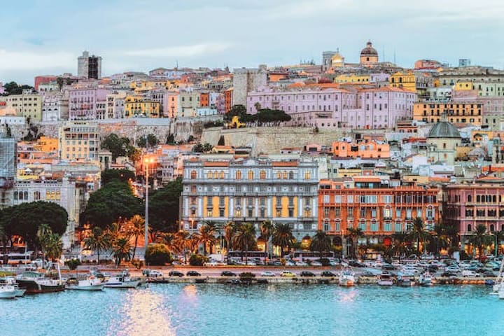
Costruita su sette colli come Roma, Cagliari è il capoluogo e la città più popolosa della Sardegna, con la sua area metropolitana di 430 mila abitanti. Fondata nel Neolitico, è con i Fenici prima e i Romani poi che diventa una vera città, grazie alla costruzione di strade, acquedotti, porti e dell’anfiteatro che si può ancora ammirare in una valletta naturale alle pendici meridionali del Colle di Buon Cammino.
È alla dominazione pisana che si deve, però, la struttura attuale su più livelli, con il sistema di bastioni e fortificazioni che caratterizzano i quartieri di Castello, Stampace, Marina e Villanova.
Passata sotto la dominazione spagnola prima e sabauda poi, Cagliari come tutta la Sardegna ha un rapporto conflittuale con la sua storia, un «legame doloroso», lo definisce, nel suo Viaggio in Sardegna, la scrittrice Michela Murgia.
Intitolata a Santa Maria Assunta, il Duomo, chiamata la cattedrale di Cagliari domina da piazza Palazzo la sottostante piazza Carlo Alberto, situata a un livello inferiore nel quartiere Castello. È incorniciata, come in una scenografia, tra le arcate dell’ottocentesco Bastione di Saint Remy.
Da vedere anche la Chiesa di Santa Croce. Riaperta al culto nel 2007, la chiesa si affaccia su una piazza chiusa tra le case dell’ex quartiere ebraico. La facciata, maestosa e difficile da fotografare, è divisa in due livelli: quello inferiore con il portone, sormontato da un timpano curvo, quello superiore decorato con lesene.
Altri simboli della città sono Cimitero monumentale di Bonaria, il Palazzo Civico, il Palazzo Regio, il Bastione di Saint Remy, Le Torri, l'Anfiteatro, costruito tra il I e il II secolo d.C e il Teatro Lirico.
Non si può lasciare Cagliari senza un gioiello in filigrana: la classica fede sarda, orecchini o bracciali da acquistare in una delle numerose gioiellerie di via Roma o di via Garibaldi.
Ogni anno, dall’1 al 4 maggio, Cagliari celebra poi il patrono Sant’Efisio. Con la festa si onora il voto perpetuo di ringraziamento fatto al santo per aver liberato, nel 1652, la città dalla peste. La celebrazione attira un gran numero di persone in città e inizia con un corteo di traccas, ovvero di carri trainati da buoi bardati a festa e seguiti da un coro, che intona antiche lodi. Gruppi di persone vestite con abiti tradizionali danzano e suonano i luneddas, strumenti a fiato formati di canne, fino all’arrivo del cocchio dorato che porta la statua del santo
Built on seven hills like Rome, Cagliari is the capital and most populous city of Sardinia, with its metropolitan area of 430,000 inhabitants. Founded in the Neolithic period, it was with the Phoenicians first and the Romans later that it became a real city, thanks to the construction of roads, aqueducts, ports and the amphitheater that can still be admired in a natural valley on the southern slopes of Buon Cammino Hill.
It is to the Pisan domination, however, that we owe the current multi-level structure, with the system of ramparts and fortifications that characterize the districts of Castello, Stampace, Marina and Villanova.
Having passed under first Spanish and then Savoy domination, Cagliari like all of Sardinia has a conflicting relationship with its history, a "painful bond," writer Michela Murgia defines it in her Viaggio in Sardegna.
Named after Santa Maria Assunta, the Duomo, called Cagliari's cathedral dominates from Piazza Palazzo the underlying Piazza Carlo Alberto, located at a lower level in the Castello district. It is framed, stage-like, between the arches of the 19th-century Bastion of Saint Remy.
Also worth seeing is the Church of Santa Croce. Reopened for worship in 2007, the church faces an enclosed square among the houses of the former Jewish quarter. The facade, majestic and difficult to photograph, is divided into two levels: the lower one with the main door, surmounted by a curved tympanum, the upper one decorated with pilasters.
Other symbols of the city are Bonaria Monumental Cemetery, the Civic Palace, the Royal Palace, the Bastion of Saint Remy, The Towers, the Amphitheater, built between the 1st and 2nd centuries AD, and the Lyric Theater.
One cannot leave Cagliari without a piece of filigree jewelry: the classic Sardinian wedding ring, earrings or bracelets to be purchased in one of the many jewelry stores on Via Roma or Via Garibaldi.
Each year, from May 1 to 4, Cagliari then celebrates the patron saint Saint Ephisius. The feast honors the perpetual vow of thanksgiving made to the saint for delivering the city from the plague in 1652. The celebration attracts a large number of people to the city and begins with a procession of traccas, or ox-drawn carts festively harnessed and followed by a choir, singing ancient praises. Groups of people dressed in traditional clothing dance and play the luneddas, wind instruments made of reeds, until the arrival of the golden chariot carrying the statue of the saint
Reeser Str. 106, 46446 Emmerich am Rhein, Alemania
Costruita su sette colli come Roma, Cagliari è il capoluogo e la città più popolosa della Sardegna, con la sua area metropolitana di 430 mila abitanti. Fondata nel Neolitico, è con i Fenici prima e i Romani poi che diventa una vera città, grazie alla costruzione di strade, acquedotti, porti e dell’anfiteatro che si può ancora ammirare in una valletta naturale alle pendici meridionali del Colle di Buon Cammino.
È alla dominazione pisana che si deve, però, la struttura attuale su più livelli, con il sistema di bastioni e fortificazioni che caratterizzano i quartieri di Castello, Stampace, Marina e Villanova.
Passata sotto la dominazione spagnola prima e sabauda poi, Cagliari come tutta la Sardegna ha un rapporto conflittuale con la sua storia, un «legame doloroso», lo definisce, nel suo Viaggio in Sardegna, la scrittrice Michela Murgia.
Intitolata a Santa Maria Assunta, il Duomo, chiamata la cattedrale di Cagliari domina da piazza Palazzo la sottostante piazza Carlo Alberto, situata a un livello inferiore nel quartiere Castello. È incorniciata, come in una scenografia, tra le arcate dell’ottocentesco Bastione di Saint Remy.
Da vedere anche la Chiesa di Santa Croce. Riaperta al culto nel 2007, la chiesa si affaccia su una piazza chiusa tra le case dell’ex quartiere ebraico. La facciata, maestosa e difficile da fotografare, è divisa in due livelli: quello inferiore con il portone, sormontato da un timpano curvo, quello superiore decorato con lesene.
Altri simboli della città sono Cimitero monumentale di Bonaria, il Palazzo Civico, il Palazzo Regio, il Bastione di Saint Remy, Le Torri, l'Anfiteatro, costruito tra il I e il II secolo d.C e il Teatro Lirico.
Non si può lasciare Cagliari senza un gioiello in filigrana: la classica fede sarda, orecchini o bracciali da acquistare in una delle numerose gioiellerie di via Roma o di via Garibaldi.
Ogni anno, dall’1 al 4 maggio, Cagliari celebra poi il patrono Sant’Efisio. Con la festa si onora il voto perpetuo di ringraziamento fatto al santo per aver liberato, nel 1652, la città dalla peste. La celebrazione attira un gran numero di persone in città e inizia con un corteo di traccas, ovvero di carri trainati da buoi bardati a festa e seguiti da un coro, che intona antiche lodi. Gruppi di persone vestite con abiti tradizionali danzano e suonano i luneddas, strumenti a fiato formati di canne, fino all’arrivo del cocchio dorato che porta la statua del santo
Built on seven hills like Rome, Cagliari is the capital and most populous city of Sardinia, with its metropolitan area of 430,000 inhabitants. Founded in the Neolithic period, it was with the Phoenicians first and the Romans later that it became a real city, thanks to the construction of roads, aqueducts, ports and the amphitheater that can still be admired in a natural valley on the southern slopes of Buon Cammino Hill.
It is to the Pisan domination, however, that we owe the current multi-level structure, with the system of ramparts and fortifications that characterize the districts of Castello, Stampace, Marina and Villanova.
Having passed under first Spanish and then Savoy domination, Cagliari like all of Sardinia has a conflicting relationship with its history, a "painful bond," writer Michela Murgia defines it in her Viaggio in Sardegna.
Named after Santa Maria Assunta, the Duomo, called Cagliari's cathedral dominates from Piazza Palazzo the underlying Piazza Carlo Alberto, located at a lower level in the Castello district. It is framed, stage-like, between the arches of the 19th-century Bastion of Saint Remy.
Also worth seeing is the Church of Santa Croce. Reopened for worship in 2007, the church faces an enclosed square among the houses of the former Jewish quarter. The facade, majestic and difficult to photograph, is divided into two levels: the lower one with the main door, surmounted by a curved tympanum, the upper one decorated with pilasters.
Other symbols of the city are Bonaria Monumental Cemetery, the Civic Palace, the Royal Palace, the Bastion of Saint Remy, The Towers, the Amphitheater, built between the 1st and 2nd centuries AD, and the Lyric Theater.
One cannot leave Cagliari without a piece of filigree jewelry: the classic Sardinian wedding ring, earrings or bracelets to be purchased in one of the many jewelry stores on Via Roma or Via Garibaldi.
Each year, from May 1 to 4, Cagliari then celebrates the patron saint Saint Ephisius. The feast honors the perpetual vow of thanksgiving made to the saint for delivering the city from the plague in 1652. The celebration attracts a large number of people to the city and begins with a procession of traccas, or ox-drawn carts festively harnessed and followed by a choir, singing ancient praises. Groups of people dressed in traditional clothing dance and play the luneddas, wind instruments made of reeds, until the arrival of the golden chariot carrying the statue of the saint